
Trail Signs
“Ride only on routes open to your vehicle.”
Mind the Signs and Motor Vehicle Use Maps
In Colorado, the Forest Service and BLM use standardized signs located at the beginning of all motorized routes. These signs use up to eight symbols in one of three different formats. A red slash through a symbol means the trail is closed to that use. If a trail has seasonal closures, the closures dates may be indicated on the sign too.
In addition, the Forest Service uses motor vehicle use maps (MVUMs) to designate which routes are open to which vehicles. MVUMs are updated annually. If there’s a conflict between the signs on the ground and the MVUM, the current year’s MVUM takes priority, for more information on MVUMs and a complete list of downloadable MVUMs, please visit our MVUM page.
The Sign Formats
These are the three different sign formats commonly seen on public lands in Colorado:
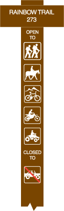
Vertical Sign or Post
The vertical sign is usually formed using reflective stickers applied to a brown flexible fiberglass post. These signs are frequently encountered at the trail head and at intersections along the trail. .
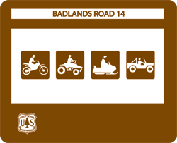
Road Sign
The road sign is common at trailheads as well as on wider routes. The sign above indicates the road is open to all OHV types. The sign can also have the words “CLOSED TO” or OHV symbols with red slashes through them to indicate that the road is closed to some OHV types.

Area Sign
When first entering an area of land managed by the BLM or Forest Service, an area sign may be posted. This sign indicates what vehicles must stay on designated routes within the area.
The Sign Symbols
There are eight symbols used on route signs in Colorado. The presence of a symbol without a red slash through it or the presence of a symbol beneath the words “OPEN TO” indicates the route is open to that use.
ATV trails are open to vehicles 50″ wide or less. Most ATVs are under 50″ in width. If an ATV has been modified to be wider than 50″ (for example, adding aftermarket wheels and tires), it can no longer be used on ATV trails and should only be used on trails open to full-size high-clearance 4WD vehicles.
There is not a sign for side-by-sides or utility terrain vehicles (UTV). If a side-by-side or UTV is over 50″ in width, the vehicle may only use trails open to full-size high-clearance 4WD vehicles. If the side-by-side or UTV is 50″ or less in width, the vehicle may use ATV trails too. Very few of these types of vehicles are 50″ or less in width.
If a symbol has a red slash through it or appears below the words “CLOSED TO”, the trail is closed to that use. Below is an example of what a symbol looks like both without and with a slash through it.

Hiker

Motorcycle

Cross-Country

ATV

Equestrian
High Clearance 4WD Vehicle

Mountain Bike

Snowmobile
Motor Vehicle Use Maps (MVUMs)
The Travel Management Rule announced in 2005 requires each National Forest and Grassland to identify and designate those roads, trails, and areas that are open to motor vehicle use. This information is documented on MVUMs. You can learn more about motor vehicle use maps from our motor vehicle use map page.
Keep Your Wheels Where They Belong!®
And finally, remember:
Drive on designated motorized routes where such designations have been made.
Where no designations have been made, drive only on existing routes until designations are made.
On public lands managed by the Forest Service, use motor vehicle use maps (MVUMs) to determine which trails and roads are open to your vehicle.
On public lands managed by the Bureau of Land Management (BLM), follow on-the-ground signs to determine which trails and roads are open to your vehicle.