
Colorado Motorized Trail Maps
The Travel Management Rule announced in 2005 requires each National Forest and Grassland to identify, designate, and map those roads, trails, and areas that are open to motor vehicle use. MVUMs are the legal record of what motorized opportunities are available on lands managed by the US Forest Service. Locate, view, and download motor vehicle use maps here.
Check Out the New Smart Maps for Colorado Public Lands!
Stay The Trail Colorado provides a central webpage where the public, organizations and agencies can download all US Forest Service Motor Vehicle Use Maps (MVUM) for National Forests and Grasslands located in Colorado. These maps are kept up to date as the US Forest Service updates their maps. Funding for this effort is provided by Colorado Parks and Wildlife in the form of grant funding that comes from registration of OHVs in Colorado. The Stay the Trail statewide “OHV Opportunities Map” is also available.
Geospatial PDFs can also be used on Apple and Android smart phones/tablets using Avenza’s free application call PDF Maps. After the PDF MVUM is downloaded on the mobile device, cellular coverage is not needed to use it. This application shows the current GPS location of the user on the map and allows them to perform some basic GPS recording tasks! The application allows you to show the location of geotagged photos you’ve taken with your mobile device right on the MVUM map. PDF Maps has an online map store that allows users of the app to find MVUMs by name or their current location! This app is being used to distribute free maps for the National Park Service, USGS Topo maps and other free maps. All MVUMs found on the Stay the Trail webpage are now also available through the Avenza map store for free!
COTREX
COTREX APP was released in the spring of 2019 by Colorado Parks and Wildlife as an effort to simplify the search for users to access new and exciting recreation areas all over the state.
This is a FREE app that displays trails for hiking, biking, horseback, and most importantly OHV trails.
This app has many great features such as: downloadable offline maps, ride tracking, featured areas/routes, GPS capabilities, information on seasonal closures/user type for over 41,000 miles of trails and much more.
Avenza App Download Instructions
iPhone
- Go to “App Store”, search for “PDF Maps” and install.
- Open “PDF Maps”, select “Store” function from the lower bar.
- Select the search function in top right corner.
- Search for “Stay The Trail” or “MVUM” or a Ranger District, select from the pins that appear.
- Use the “Free” button to download to the phone.
- Downloaded maps show up in the “Maps” list on the lower left.
- Select appropriate map for the district’s trails you will be using. Your location appears using GPS sensor.
Android
- Go to “Play Store”, search for “PDF Maps” and install.
- Open “PDF Maps”, select “Store” function from the lower bar.
- Select the search function in top right corner.
- Search for “Stay The Trail” or “MVUM” or a Ranger District, select from the pins that appear.
- Use the “Free” button to download to the phone.
- Downloaded maps show up in the “Maps” list on the lower left.
- Select appropriate map for the district’s trails you will be using. Your location appears using GPS sensor.
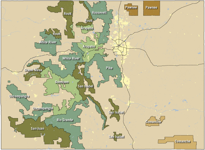
Motor Vehicle Use Maps
Arapaho National Forest
Official Forest Service MVUM Page for this Forest
- Clear Creek Ranger District
- Sulphur Ranger District North
- Sulphur Ranger District South
Cimarron National Grassland (Kansas)
Official Forest Service MVUM Page for this Forest
- Cimarron National Grassland
Comanche National Grassland
Official Forest Service MVUM Page for this Forest
- Comanche National Grassland East
- Comanche National Grassland West
- Comanche National Grassland East-Inset
Grand Mesa National Forest
Official Forest Service MVUM Page for this Forest
- Grand Mesa Division
Gunnison National Forest
Official Forest Service MVUM Page for this Forest
- Gunnison Ranger District North
- Gunnison Ranger District South
- Paonia Ranger District
Pawnee National Grassland
Official Forest Service MVUM Page for this Forest
- Pawnee National Grassland East
- Pawnee National Grassland West
Pike National Forest
Official Forest Service MVUM Page for this Forest
- Pikes Peak Ranger District
- South Platte Ranger District West
- South Platte Ranger District East
- South Platte Ranger District East-Inset
- South Park Ranger District West
- South Park Ranger District East
Rio Grande National Forest
Official Forest Service MVUM Page for this Forest
- Conejos Peak Ranger District East
- Conejos Peak Ranger District West
- Divide Ranger District East
- Divide Ranger District West
- Saguache Ranger District East
- Saguache Ranger District West
Roosevelt National Forest
Official Forest Service MVUM Page for this Forest
- Boulder Ranger District
- Canyon Lakes Ranger District North
- Canyon Lakes Ranger District South
- Canyon Lakes Ranger District Errata-1
- Canyon Lakes Ranger District Errata-2
Routt National Forest
Official Forest Service MVUM Page for this Forest
- Hahns Peak/Bear Ears Ranger District
- Hahns Peak Ranger District-Inset
- Hahns Peak Ranger Dist-Lost Dog-Inset
- Parks Ranger District
- Parks Ranger District-Inset
- Yampa Ranger District
- Yampa Ranger District Bear River-Inset
San Isabel National Forest
Official Forest Service MVUM Page for this Forest
- Leadville Ranger District
- Salida Ranger District
- San Carlos Ranger District North
- San Carlos Ranger District South
San Juan National Forest
Official Forest Service MVUM Page for this Forest
- Columbine Ranger District-Front Map
- Columbine Ranger District-Back Table
- Beaver Meadows Sauls Creek Travel Map
- HD Mountains and Lakes Travel Map
- Columbine Lakes Area Travel Map
- Dolores Mancos-Cortez Travel Map-Pg 1
- Dolores Mancos-Cortez Travel Map-Pg 2
- Dolores Ranger District
- Pagosa Ranger District
Uncompahgre National Forest
Official Forest Service MVUM Page for this Forest
- Plateau Division
- Mountain Division
White River National Forest
Official Forest Service MVUM Page for this Forest
- Aspen/Sopris Ranger District
- Dillon Ranger District
- Dillon Ranger District-Inset
- Eagle/Holy Cross Ranger District-Front
- Eagle/Holy Cross Ranger District-Back
- Flat Tops (Blanco-Eagle) Ranger District
- Rifle Ranger District
Colorado River Valley BLM Field Office
- Bocco Mountain
- Bocco Mountain-Page 2
- Cedar Mountain
- Gypsum Hills
- Hardscrabble
- Hubbard Mesa
- McCoy Trail
- Roan Plateau
- Silt Mesa
- The Crown
Grand Junction BLM Field Office
Gunnison BLM Field Office
Gunnison Gorge National Conservation Area
Kremmling Field BLM Office
Little Snake BLM Field Office
Royal Gorge BLM Field Office
San Luis Valley BLM Field Office
Tres Rios BLM Field Office
Uncompahgre BLM Field Office
White River BLM Field Office